
There are Gold Coast experiences that look better in photos than in person, and then there is Natural Bridge. Step inside the cave at the end of this easy one-kilometre rainforest walk and the ceiling above you becomes a living planetarium: thousands of blue-green bioluminescent larvae, each one hanging its own silk threads like a tiny fishing line, together painting the cave roof in a constellation that has nothing to do with the stars and everything to do with survival. It is one of the most genuinely otherworldly things you will see in Queensland, and the walk costs you nothing.
Natural Bridge sits in the Numinbah section of Springbrook National Park, about an hour south-west of Surfers Paradise. It is separate from the main Springbrook plateau, sitting lower and warmer in a subtropical gorge carved by Cave Creek over millions of years. The result is a place that feels more intimate than a typical national park attraction: dense rainforest, a thundering waterfall framed by a natural rock arch, and a cave that puts on a better light show after dark than most ticketed venues in the city. You can do it as a standalone visit or use it as the anchor for a full day in the Gold Coast hinterland.
| Feature | Details |
|---|---|
| Entry Cost | Free (no park entry fee) |
| Walk Distance | 1 km circuit |
| Walk Grade | Easy (Grade 2), some stairs |
| Time Needed | 1 hour self-guided; 2-3 hours on a guided night tour |
| Glow-Worm Best Time | After sunset year-round; peak display December to March |
| Best For | Families, couples, first-time rainforest visitors, wildlife enthusiasts |
| Kid Friendly | Yes, well-suited for children 5 and up |
| Parking | Free carpark at trailhead |
| Nearest Town | Nerang (~25 km); Gold Coast (~1 hour) |
| Public Transport | No. Car or guided tour required |
Who It Suits
Natural Bridge is the rare attraction that genuinely works for almost everyone. Families with young children will love the short, easy circuit and the spectacle of a cave full of living lights. Couples looking for a dusk-to-dark experience will find the cave quietly extraordinary in ways that no restaurant view can replicate. Photography enthusiasts can spend an hour inside attempting long-exposure shots of the bioluminescence. Travellers with one free afternoon from the beach who want something that feels genuinely different will not be disappointed.
If you have limited mobility, note that the circuit includes stairs and some uneven terrain. A guided tour with a knowledgeable operator is the best option in that case. And if you are visiting purely for the glow-worms, plan your timing carefully: arriving in daylight lets you see the waterfall and arch at their photogenic best, but you will need to stay through sunset, or return after dark, for the full cave display.
23 Million Years in the Making: The Geology of Natural Bridge
The arch you walk beneath is not a quirk of nature. It is the product of an ancient volcanic event, relentless water erosion, and about 23 million years of slow, patient geology.
The story begins with the Tweed Shield Volcano, centred on Wollumbin (Mount Warning) to the south. Roughly 23 million years ago, this immense shield volcano dominated the region, pouring basalt lava flows across 6,000 square kilometres. Some flows reached 270 metres deep. The entire landscape of the Gold Coast hinterland, from Springbrook’s sheer cliffs to the Numinbah Valley floor, sits on the eroded remains of that volcano’s northern rim. The Tweed Shield erosion caldera is considered one of the best preserved of its type in the world.
Natural Bridge itself is what happens when water spends millennia working on basalt. A waterfall once fell over a lip of hard volcanic rock. At its base, softer broken-up basalt was gradually eroded by swirling water, undercutting the falls and hollowing out a cave beneath. Simultaneously, rocks in the stream bed above swirled in the current, drilling a pothole downwards until it broke through to the cave below. When the two connected, Cave Creek poured into the cave instead of over the lip, and the old waterfall’s edge became the bridge. The cave has continued to erode ever since.
Here is the detail that makes geologists smile: another pothole is currently forming in the creek bed above the cave and is already leaking water into the space below. Given enough time, a second breakthrough will occur. The geology here is not finished.
Other striking volcanic formations in the wider area include Egg Rock and Pages Pinnacle in the Numinbah Valley, and the twin rhyolite peaks of Mount Cougal. Visit the Best of All Lookout on the plateau for the clearest view of the caldera’s scale: a crescent of perpendicular cliffs that extends from Springbrook to Lamington and the Tweed Range, all that remains of one of the largest ancient volcanoes in the southern hemisphere.
The Glow-Worm Cave: What It Is Actually Like
Nothing quite prepares you for the moment the cave comes into view. The waterfall drops through the rock arch at one end of the cave chamber, catching just enough ambient light to shimmer. The rest of the cave roof is another matter: it is dark, and then your eyes adjust, and then there are thousands of them.
The glow-worms at Natural Bridge are Arachnocampa flava, a species found only in Australia and New Zealand, and specifically dependent on Gondwanan rainforest for their survival. They are not actually worms. They are the larval stage of a small fly, and what you are seeing is bioluminescence produced by four chemicals reacting inside the larva’s body. The light is cold (no heat), blue-green, and produced for a single purpose: to lure prey.
Each larva hangs dozens of sticky silk threads from the cave roof, sometimes up to 40 centimetres long, like a miniature fishing line coated in mucus. Midges, mosquitoes and mayflies drawn to the light fly into the threads and are hauled up to be eaten. The larva feeds for about nine months. When it pupates, the adult fly that emerges lives for just three to four days, long enough only to mate and lay eggs. Then the cycle begins again.
Natural Bridge is home to Australia’s largest population of glow-worms, and the cave maintains a stable temperature year-round, meaning the display is on every night. The most spectacular shows occur in the warmer, wetter months from December through March, when the colony is most active. On a good summer night, the cave roof looks almost exactly like a clear night sky viewed from the middle of nowhere. The “nature’s planetarium” description that tour operators use is not marketing. It earns its name.
As Arachnocampa species go, this lineage is ancient, surviving in humid cave and rainforest conditions as the Australian continent drifted north and dried out over millions of years. Seeing them here, in a cave carved by a 23-million-year-old volcanic landscape, in a rainforest with Gondwanan origins: there is genuine time depth to this experience if you want to look for it.
A strict set of rules applies inside the cave, and they exist to protect the colony rather than inconvenience you. Do not shine torches or phone screens directly at the cave roof. Do not use insect repellent before entering (it is lethal to the larvae, apply it before leaving the carpark if needed, not near the cave entrance). Do not smoke in or near the cave. Keep voices low. The glow-worms will dim or switch off entirely in response to bright light and disturbance, and they take time to recover. Give it ten minutes in darkness and they will usually return to full display.
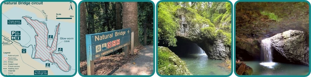
The Natural Bridge Circuit Walk
The walk is a 1-kilometre loop rated Grade 2 (easy), and most visitors take around an hour including time at the cave. It starts at the carpark off Nerang-Murwillumbah Road, descends through subtropical rainforest on a combination of boardwalks, stairs and concrete paths, reaches the arch and cave at the bottom, and loops back up to the start via the other side of Cave Creek.
Walk clockwise: this sends you down the stairs section first (easier on the knees) and returns you on the gentler grade. The descent is roughly 60 metres in elevation, manageable for most adults and children from about age five upward.
What you will notice on the way down is the shift in microclimate. The air cools and becomes noticeably more humid as you descend into the gorge. The canopy closes overhead, filtering the light to a deep, damp green. Strangler figs and hoop pines tower on either side. The creek becomes audible before you can see it.
Arriving at the arch in daylight, the waterfall drops through the rock bridge into the cave below. Both golden hour and overcast conditions produce good photography conditions. The creek pool below the arch is subject to permanent restricted access rules: swimming and entering the creek bank between the upper and lower bridges is prohibited, with fencing installed to enforce this. The ban exists for two reasons: the rock face above the creek is potentially unstable and is monitored by geotechnical engineers, and foot traffic through the creek bank destroys the insect larvae that form the base of the glow-worm food chain. Penalties apply under Queensland law.
Inside the cave, allow your eyes to adjust before reaching for a torch. If you arrive after sunset, the display should be immediately visible once you step inside. Take your time. The cave is not large, but the ceiling above it justifies a slow, quiet visit.
| Detail | Info |
|---|---|
| Distance | 1 km loop |
| Grade | Easy (Grade 2) |
| Time | ~1 hour |
| Surface | Boardwalk, stairs, concrete path |
| Elevation Change | ~60 m descent/ascent |
| Recommended Direction | Clockwise |
| Accessibility | Not wheelchair-accessible (stairs) |
| Night Visits | Bring a torch or headlamp |
The Bigger Picture: Natural Bridge as Part of Springbrook National Park
Natural Bridge is one of four sections that make up Springbrook National Park, and understanding the bigger picture pays dividends for planning your day. The other sections (Springbrook Plateau, Mount Cougal and Numinbah) are each accessed via separate roads and offer a different experience.
The plateau section, reached via the winding Springbrook Road from Nerang, is where you will find the park’s most dramatic landscapes: the 80-metre Purling Brook Falls, the canyon walks through ancient Antarctic beech forest, and the Best of All Lookout with its sweeping view across the Tweed caldera. Combining Natural Bridge at dusk with a morning on the plateau makes for one of the best full-day hinterland experiences on the Gold Coast.
Walking Tracks in the Wider Springbrook Network
| Track | Distance | Time | Grade | Highlights |
|---|---|---|---|---|
| Natural Bridge Circuit | 1 km loop | ~1 hr | Easy (2) | Rainforest boardwalk, rock arch, glow-worm cave |
| Twin Falls Circuit | 4 km loop | ~2 hr | Moderate (3) | Two waterfalls, subtropical gorge, canyon views |
| Purling Brook Falls Circuit | 4 km loop | ~2 hr | Moderate (3) | 80 m waterfall, Antarctic beech, suspension bridge |
| Best of All Lookout | 0.6 km return | ~30 min | Easy (2) | Cliff-top views over Numinbah Valley and coast |
| Warrie Circuit | 14 km loop | 5-6 hr | Hard (4) | Remote rainforest, Goomoolahra Falls (check current alerts) |
| Cascades Track (Mt Cougal) | 1.6 km return | ~1 hr | Easy (2) | Sealed boardwalk, Currumbin Creek, historic sawmill |
| Buliya-Buliya Boardwalk | 100 m loop | 5 min | Very Easy (1) | Elevated rainforest loop near Purling Brook carpark |
Always check current Queensland Parks alerts before heading out. Track conditions and closures can change with weather, and infrastructure works are ongoing in parts of the park. Maps for all these trails are also available on the QLD Parks website.
Flora: What Is Growing in This Gorge
The vegetation around Natural Bridge is subtropical rainforest at its most textbook-perfect: a dense closed canopy of strangler figs, hoop pines, palms and epiphytes, dripping year-round from the high annual rainfall and the spray of Cave Creek. Walk into this gorge and you are moving through one of the most primitive plant communities on the continent.
The hoop pine (Araucaria cunninghamii) is a Jurassic relic, a conifer whose lineage predates flowering plants. The giant specimens in the gorge have been growing here for centuries. Strangler figs germinate in the fork of a host tree, send roots to the ground and gradually encase the trunk until the host dies within, leaving a hollow-trunked fig that becomes important wildlife habitat in its own right.
Higher up the slopes as you return on the circuit, the forest type shifts toward warm temperate rainforest. On the Springbrook plateau above, Antarctic beech (Nothofagus moorei) groves survive at altitude in the cool mist, some of them around 3,000 years old. These beech trees are cold-climate relics from when Australia was still part of the Gondwana supercontinent. They persist here on the lip of an ancient volcano, some of the oldest living things you are likely to stand near on a day trip from the Gold Coast.
Springbrook’s subtropical rainforests also hold a small population of the critically endangered southern ochrosia (Ochrosia moorei), with fewer than 20 plants remaining in Queensland. This is believed to be one of the last habitats on earth where it grows.
Along the creek banks, look for blue spiny crayfish in the clear water and lawyer vine tangling through the understorey. After rain, the track is dense with fungi, ferns unfurling from the ground, and moss covering every surface that holds moisture. The wildflower season (spring through summer) brings cascades of sarsaparilla vine in flower through the canopy, and wattles burst on the drier ridges in winter.
Fauna: Who Lives Here
The cave glow-worms rightly get top billing, but Natural Bridge and the surrounding Numinbah section hold rich wildlife habitat well beyond the cave roof. Here is what you might encounter.
Birds
Over 100 bird species have been recorded in Springbrook National Park. The one visitors most want to see but rarely do is Albert’s lyrebird, found only in a narrow belt of rainforest in south-east Queensland and north-east New South Wales. It is most often heard rather than seen, producing an extraordinary mimicking song from deep in the valley. The best time is winter, when males are most vocal. If you hear what sounds like another bird’s call, followed by another, followed by something electronic, you are probably listening to a lyrebird.
More reliably spotted are the crimson rosella (scarlet and royal blue, impossible to miss in any light), yellow-tailed black cockatoos feeding in banksias and casuarinas, and the regent and satin bowerbirds in the understorey. The slender-billed cuckoo-dove calls a distinctive “oop-oop” throughout the gorge all day. Smaller track-side birds include the yellow robin, rufous fantail and superb fairy-wren.
Mammals
Red-necked pademelons, small wallabies of the rainforest, are commonly seen at dusk along road edges and track margins. Drive slowly approaching the carpark at that hour. Brushtail and ringtail possums are active after dark, and sugar gliders and greater gliders can be spotted with a red-filtered torch on the larger trees along the circuit. The vulnerable spotted-tailed quoll, mainland Australia’s largest marsupial carnivore, ranges through the park but is rarely seen (look for corkscrew-shaped droppings on flat rocks near boulder fields if you want evidence of its presence). Platypus inhabit the larger pools of the upper Nerang River a short distance from the valley floor.
Frogs
At least 35 frog species live in Springbrook National Park. On humid nights, the Natural Bridge circuit comes alive with them. Orange-eyed treefrogs and great barred frogs are often seen sitting directly on the path or on logs near the creek. The giant barred frog (Mixophyes iteratus), Australia’s largest frog and an endangered species, is present here. So is Fleay’s barred frog (Mixophyes fleayi), named after Queensland naturalist David Fleay, which is equally endangered and equally dependent on clean, undisturbed stream habitat. Seeing either species on the track after rain is a rare and genuinely significant encounter.
Reptiles and Other Fauna
Lace monitors (goannas) are the most commonly seen reptile, often foraging along the creek banks and around the carpark bins (they are opportunists). The glossy black land mullet skink is distinctive and fast. Carpet pythons are present and harmless if unprovoked. Stand well clear of any snake you encounter and give it time and space to move on.
Look out too for the blue spiny crayfish in the creek and, if exceptionally fortunate, the Richmond birdwing butterfly. The invertebrate fauna here traces its origins back to Gondwana, with some species having changed little over 400 million years.
Seasonal Notes
Glow-worm activity peaks December to March. Frog calls peak in late spring and summer after rain. The best birdwatching (including the best chance of hearing Albert’s lyrebird) is in the cooler months from May through August. Waterfalls are at their most dramatic from November through March following rainfall. Summer brings warm, humid nights but also the occasional afternoon storm: check the forecast and plan your timing accordingly.
Conservation: What Is Being Protected and Why It Matters
Springbrook National Park is part of the Gondwana Rainforests of Australia World Heritage Area, inscribed by UNESCO in 1994. The listing recognised the park’s extraordinary geology, its subtropical and cool temperate rainforests, and its role as a refuge for species with ancient Gondwanan origins. The glow-worms are part of this story. Arachnocampa survived in the humid, dark conditions of rainforests and caves as the Australian continent drifted north and dried out over millions of years. The Natural Bridge cave is not incidental to the World Heritage listing. It is an argument for it.
The threats to this place are real. Chytrid fungus has devastated frog populations across Australia and is present in this park. Lantana and exotic vines compete aggressively in disturbed forest margins. Climate change is altering rainfall patterns and increasing fire risk, even in this notoriously wet corner of Queensland. In the Numinbah Valley below, much of the surrounding land was cleared for dairy farming in the early twentieth century, isolating the park’s rainforest in a matrix of degraded land.
The response has been active. The Springbrook Rescue program, run by the Australian Rainforest Conservation Society, has recruited more than 200 volunteers to plant indigenous trees on former farmland on the plateau, gradually reconnecting fragmented rainforest patches and restoring wildlife corridors. The program has reforested hundreds of hectares since the 1990s.
Queensland Parks and Wildlife Service manages ongoing weed control, feral animal management and fire management across the park. Recovery plans are in place for the spotted-tailed quoll, the endangered barred frogs and other threatened species. The swimming ban and restricted access rules in the Cave Creek corridor are a direct conservation measure, not bureaucratic caution. The insect larvae in the creek silt are the food source for the glow-worms. When visitors trample the creek bank, those larvae are washed away. The glow-worm colony at Natural Bridge is irreplaceable, and it depends on the health of the entire creek ecosystem to survive.
Visitors can support the Springbrook Rescue program directly. Information on volunteering and donations is available at arcs.org.au.
Country of the Yugambeh: Indigenous History and Connection
Springbrook National Park sits on the Country of the Yugambeh people, whose eight clans, including the Kombumerri, Mununjali, Wangerriburra, Bullongin, Gugingin, Tulgingin, Cudgenburra and Murangmuburra, are connected by language and by the deep relationships between clans that enabled movement across this country for trade, ceremony and family. The Yugambeh are the traditional coastal and hinterland people of the Gold Coast region, and their connection to this landscape is continuous across thousands of years.
To the Yugambeh, the mulei (mountains) are sacred. Creation stories describe how the mountains and valleys, the balun (rivers) and the munan (hard-baked dry land) were shaped by ancestral forces, and those stories were encoded into song, dance and ceremony, passing practical knowledge of the landscape between generations. The watercourses that feed Cave Creek and power the waterfall at Natural Bridge are part of this cosmology, not incidental features of scenery.
The Yugambeh managed this country with intention and care. Fire was used to modify vegetation, encourage food species and maintain pathways. Trade networks connected hinterland communities with coastal clans, exchanging stone tools and rainforest products for coastal foods including dugunum (shellfish) from the borrogura (sea). Ngabul (lawyer vine) served as a tree-climbing tool. The rainforest was a cultivated, known, storied place, not wilderness.
European arrival changed the Numinbah Valley profoundly. Timber-getters reached the area in the 1870s. A giant red cedar felled near Natural Bridge in 1893 was so impressive a specimen that a cross-section was sent to the 1900 Paris World Fair. Large areas of the valley were cleared for dairy farming by the 1920s. The Natural Bridge scenic reserve was declared in 1922, recognised even then as needing protection. It became a national park in 1959 and was incorporated into Springbrook National Park in 1990.
The first Europeans to survey the plateau in 1863 were assisted greatly by Bilin Bilin and other Yugambeh First Nations people who guided surveyors Francis Roberts and Isaiah Rowland through terrain so rugged that early official reports concluded settlement “will never take place until flying machines are in general use.” Roberts documented place names in Yugambeh language throughout his field notes. Many persist today in the park’s formal place names.
Today, Queensland Parks signage acknowledges Yugambeh Country and shares language and stories in its interpretation. The Yugambeh community continues to live on and care for their traditional lands. Their own statement on the parks website says it plainly: Yugambeh yahnbai gulli bahn. Yugambeh are still here.
For those interested in Yugambeh language and heritage, the Yugambeh Museum Language and Heritage Research Centre in Beenleigh is the primary resource and well worth a visit in its own right.
Full Day Itinerary Options
Natural Bridge alone takes about an hour. But it sits within reach of the rest of Springbrook National Park, making it the ideal anchor for a full Gold Coast hinterland day. Here are three itinerary options designed for different travel styles.
Option 1: The Family Day (6-7 hours)
Arrive at the Natural Bridge carpark by 8:30am. The morning walk gives children the chance to spot wildlife on the track and fully appreciate the waterfall and arch while there is good light. Bring a picnic and eat at the tables near the carpark. By 10:30am, drive up the Springbrook Road to the plateau (approximately 40 minutes) and tackle the Best of All Lookout track (0.6 km, 30 minutes return), which rewards minimal effort with a spectacular view across the caldera. From there, drive to the Gwongorella day-use area for the Purling Brook Falls circuit (4 km, 2 hours), where an 80-metre waterfall and suspension bridge over the creek are reliably impressive for all ages. Return to the coast for dinner, or if children can handle a late night, return to Natural Bridge at dusk for the glow-worm display. Two hours after sunset is usually enough for the full experience.
Option 2: The Dusk-to-Dark Glow-Worm Experience (Half Day)
Arrive at Natural Bridge in late afternoon, around 4pm, and walk the circuit in the remaining daylight to see the arch and waterfall properly. Bring food and drinks and wait out the gap at the picnic tables. As sunset approaches, re-enter the circuit and time your arrival at the cave for 30 to 45 minutes after dark. The glow-worm display intensifies as the night deepens. Allow a full hour inside the cave without rushing. This works best in summer when sunsets are later (around 7pm), giving you a full afternoon of rainforest time before the cave comes alive. A guided night tour takes the logistics off your hands and adds expert commentary to the experience. See the tour operators section below.
Option 3: The Full Hinterland Loop (9-10 hours, active)
Begin at 7:30am on the Springbrook plateau with the Twin Falls Circuit (4 km, 2 hours), starting at Canyon Lookout carpark. The gorge walk is dramatic and largely crowd-free at that hour. Walk to Canyon Lookout itself for the caldera view, then drive to Best of All Lookout (30 minutes on the track, worth every step). Drive to the Gwongorella area and walk the Purling Brook Falls Circuit (4 km, 2 hours) with a stop at Warringa Pool if the designated swimming area is accessible. Late lunch in Springbrook township. In the afternoon, drive down to Natural Bridge (40 minutes from the plateau) and arrive with a couple of hours to spare before dusk. Do the circuit in the last light, then return after sunset for the glow-worms. Carry 2 litres of water per person, wear solid footwear and check park alerts before you go.
Guided Night Tours to Natural Bridge
You can visit Natural Bridge completely independently, any time of year, at no cost. But a guided night tour adds genuine value: transport from the Gold Coast (no driving winding mountain roads after dark), expert commentary on the glow-worms and rainforest ecology, and the reassurance of a knowledgeable guide on an unfamiliar dark track.
Queensland Parks restricts the number of commercial tour permits to protect the glow-worm colony, so operators must be accredited.
- Tour Gold Coast: Holds more permits than any other operator, with Advanced Eco Tourism accreditation. Tours depart from Gold Coast hotels and include the circuit walk, cave viewing, and stargazing sessions when conditions allow. Highly recommended for first-timers and solo travellers.
- Southern Cross Tours: Gold Coast hinterland specialists offering guided day and evening tours combining Natural Bridge with other Springbrook highlights.
- Viator, GetYourGuide, ExperienceOz: Booking platforms listing multiple accredited operators, useful for comparing inclusions and reading recent visitor reviews. Search “Natural Bridge glow worm Gold Coast” on any of them for current listings, pricing and availability.
Tours typically run for 2-3 hours and include hotel pick-up by air-conditioned coach. Prices vary by operator and season. Book ahead in the summer peak season (December to March) when the display is at its best and tour slots fill quickly.
Camping Options
There is no camping within the Natural Bridge section itself. The nearest national park campground is on the Springbrook plateau, about 40 minutes’ drive away.
The Settlement Camping Area, Springbrook Plateau
The Settlement is the only campground inside Springbrook National Park, sitting at approximately 900 metres altitude adjacent to the Springbrook Information Centre and a short walk from the top of Purling Brook Falls. It has 11 unpowered sites with gravel pads, pit toilets, drinking water, a covered cooking shelter with electric BBQs, and picnic tables. No showers, no rubbish bins, no open fires, no generators. Maximum two-night stay. Bookings are essential via Queensland Parks online. It is a genuinely lovely spot, cool even in midsummer, with Albert’s lyrebirds calling from the valley below at dawn. Bring rain gear regardless of the forecast.
Nearby Options
| Option | Location | Type | Notes |
|---|---|---|---|
| O’Reilly’s Rainforest Retreat | Lamington NP | Campground + cabins | Powered and unpowered sites, showers, camp kitchen, on-site shop. Book direct. |
| Binna Burra Mountain Lodge | Lamington NP | Campground + lodge | Powered and unpowered sites, amenities block and camp kitchen. Book direct. |
| Woonoongoora Walkers’ Camp | Numinbah Conservation Area | Walk-in tent only | Basic (pit toilets, water tank only). Part of the Gold Coast Hinterland Great Walk. Book via QLD Parks. |
Maps and Navigation Resources
The Natural Bridge circuit is well-signposted and practically impossible to get lost on. For the wider Springbrook network, particularly the longer Warrie Circuit, bring a map and download offline navigation before you lose mobile signal on the drive in.
- Queensland Parks walking track maps: Free PDF downloads of Springbrook NP walking tracks, the Settlement camping area and all sections. Print these before you go.
- QTopo (Queensland Spatial Digital Atlas): Recommended for offline topographic maps covering the Gondwana Rainforests. Download the relevant map sheet before leaving Nerang.
- AllTrails: The Natural Bridge Circuit and most Springbrook tracks are listed with GPS traces and user reviews. Useful for planning, but supplement with a printed map on longer routes.
- BOM Weather app: Check forecasts for both the Springbrook Plateau and Numinbah Valley before heading out. The plateau receives over 3,000 mm of rain annually. Heavy rain can close tracks without warning. Even clear forecasts can produce afternoon showers in summer.
Cell coverage is poor to non-existent in the Natural Bridge gorge and in canyon areas on the plateau. Plan accordingly and always let someone know your route and expected return time on longer walks.
What Locals Know
The carpark at Natural Bridge fills fast on weekend mornings, particularly in summer and during school holidays. Arrive before 9am to be certain of a space, or after 3pm when the daytime visitors are leaving and the evening crowd has not yet arrived. This late afternoon window is actually ideal: you catch the waterfall in good light and then stay through sunset for the cave display.
The glow-worm display varies night to night. It is affected by recent weather (heavy flooding temporarily disturbs the colony), by how many groups have come through before you (bright torches and noise reduce the display for subsequent visitors), and to a lesser extent by season. Post-midnight hours, after tour groups have finished for the evening, often produce the quietest and most uninterrupted viewing. If you are self-guiding and the display seems dim, wait ten minutes in darkness before deciding the colony is not performing.
The Nerang-Murwillumbah Road through the Numinbah Valley is genuinely beautiful driving. Do not rush it. There are lookout points along the valley floor that most visitors miss entirely because they are focused on the destination. The valley floor farming communities, the dramatic valley walls rising on both sides, and the transition from coastal suburbia to rainforest mountain country is itself worth a slow drive.
The road to the Springbrook plateau (Springbrook Road from Nerang) is steep, narrow and winding. Allow considerably more time than navigation apps suggest, especially after rain when the road can be slippery. Trailers and caravans are not permitted on some sections due to narrow bridges.
Finally, and importantly: wear insect repellent on the way in if you need it, but apply it before you leave the carpark. Inside the cave, insect repellent is lethal to the glow-worms. This is the single most important practical tip for the visit, and it is one that a surprising number of visitors only learn about after the fact.
Getting There
From the Gold Coast: Head west on the Pacific Motorway (M1) and take Exit 77 for Nerang. From Nerang, follow the Nerang-Murwillumbah Road south-west through the Numinbah Valley. Natural Bridge is signposted on the left after approximately 25 kilometres. Allow 55-65 minutes from Surfers Paradise.
From Brisbane: Take the M1 south to Exit 77 (Nerang), then as above. Allow approximately 1.5 hours from the Brisbane CBD.
Public transport: There is no public transport to Natural Bridge or anywhere in Springbrook National Park. A car or guided tour with hotel pick-up is the only practical option.
Parking: Free gravel carpark at the trailhead. No fee. Fills on weekend mornings and during school holidays.
Practical Information
| Detail | Info |
|---|---|
| Entry fee | Free |
| Open | 24 hours, year-round |
| Camping permits | Required for overnight stays. Book via Queensland Parks online |
| Dogs/pets | Not permitted in national parks |
| Toilets | At the Natural Bridge carpark |
| Facilities | Picnic tables, information shelter at trailhead |
| Queensland Parks phone | 13 74 68 |
| Park alerts | parks.qld.gov.au/park-alerts |
| Springbrook Info Centre | GaurieMABAH schoolhouse on plateau, Mon-Fri 8:00-15:30 |
Is It Worth It?
Yes, without qualification. The Natural Bridge glow-worm cave is one of a small number of Queensland experiences that genuinely delivers on the description. It is free, it is accessible, and a colony of thousands of bioluminescent larvae illuminating a volcanic cave beneath a subtropical rainforest waterfall is exactly as remarkable as it sounds. You do not need a tour company, a large budget, or a week to spare. You need an hour, a torch, and the restraint to turn your phone screen off inside the cave.
If you have more time, Natural Bridge is the launching pad for one of the Gold Coast’s best full days out. The Springbrook plateau above is a different world entirely: cooler, more rugged, with bigger waterfalls, 3,000-year-old beech trees and cliff-top views across 23 million years of volcanic geology. The combination of a day on the plateau and Natural Bridge at dusk gives most visitors everything they hoped for from the hinterland, and usually considerably more.
Frequently Asked Questions
Is it free to visit Natural Bridge?
Yes. There is no entry fee to Springbrook National Park. The carpark is free, the walk is free, and you can visit the glow-worm cave at night completely independently at no cost. Guided tours are optional and add transport and commentary, not access.
When is the best time to see the glow-worms?
The glow-worms are visible any night of the year, as the cave maintains a stable temperature. The peak display is from December through March, when the colony is most active and nights are warmest. Arrive at least 30 minutes after sunset and allow your eyes to adjust inside the cave. Do not shine torches at the cave roof.
Can you swim at Natural Bridge?
No. Swimming in Cave Creek and access to the creek bank between the upper and lower bridges is permanently prohibited. The ban protects both visitors (the rock face above the creek is potentially unstable) and the glow-worm colony (creek bank trampling destroys the insects that form the glow-worms’ food source). Fines apply under Queensland law.
How hard is the Natural Bridge circuit walk?
It is an easy Grade 2 walk, 1 kilometre in length, taking around one hour. There are stairs on the descent and return. It is suitable for families with children from around age five, though it is not wheelchair-accessible. Good footwear is recommended as sections can be slippery after rain.
Do I need a guided tour or can I self-guide?
Self-guiding is completely viable. The circuit is well-marked and the cave is clearly signposted at the end of the trail. Bring a torch (a headlamp is ideal), apply insect repellent before you leave the carpark rather than near the cave entrance, and keep lights off the cave roof inside. Guided tours add value if you want transport from the Gold Coast, expert naturalist commentary, or the confidence of a small group on an unfamiliar dark track.
Is Natural Bridge suitable for children?
Yes, it is one of the more reliably family-friendly walks in the Gold Coast hinterland. The short distance and manageable terrain suit children from about age five. The glow-worm cave is an extraordinary experience for children, and the waterfall through the arch is reliably impressive at any age. Keep children away from the creek bank and explain the cave rules clearly before entering.
What other walks can I do nearby?
Natural Bridge is approximately 40 minutes’ drive from the Springbrook plateau, where the Twin Falls Circuit (4 km, moderate), the Purling Brook Falls Circuit (4 km, moderate), the Best of All Lookout (0.6 km, easy) and the demanding Warrie Circuit (14 km, hard) are all available. Always check current park alerts for track closures before planning longer walks.
Where can I camp near Natural Bridge?
The nearest national park campground is The Settlement on the Springbrook plateau (approximately 40 minutes’ drive). It has 11 unpowered sites and must be booked in advance via Queensland Parks online. Private options including O’Reilly’s Rainforest Retreat and Binna Burra Mountain Lodge in Lamington National Park offer more facilities and are worth considering for an extended hinterland stay.
What is the history of Natural Bridge?
The Numinbah Valley and Natural Bridge sit on Yugambeh Country, where Indigenous Australians have lived and managed country for thousands of years. European timber-getters reached the area in the 1870s, and a giant red cedar felled near Natural Bridge in 1893 was so remarkable that a cross-section was displayed at the 1900 Paris World Fair. Natural Bridge was declared a Recreation and Scenic Reserve in 1922, became a national park in 1959, and was incorporated into Springbrook National Park in 1990. It was part of the broader Gondwana Rainforests UNESCO World Heritage listing in 1994.
For the latest information, park alerts and camping bookings, visit parks.qld.gov.au/parks/springbrook or call Queensland Parks on 13 74 68.
National Park, Springbrook QLD 4213, Australia